One of the most epic adventures you can have in Western Australia is embarking on the Gibb River Road road trip.
Gibb River Road is the ultimate off-road journey with more than 70% of the road being unsealed and all-terrain. We have done parts of it when we lived in Broome working on a pearl farm AND when we did our 18 month road trip around Australia.
We haven’t done the full road trip as we did not have high enough clearance for the Pentecost River crossing and did not want to risk getting stuck in a crocodile infested river!!
Pentecost River Crossing, Gibb River Road
If you’re thinking about driving the Gibb River Road, you will need a high-clearance 4WD vehicle, adequate supplies, and fuel, and a thorough understanding of road conditions and potential hazards to make it from one end to the other without a hitch.
This is why we’ve prepared this guide so you can embark on this incredible adventure completely prepared and clued up on what to expect.
History of the Gibb River Road
El Questro
The Gibb River Road is a 660km road that extends from Derby to Kununurra in Western Australia that was originally built as a cattle route in the 1960s, connecting the remote cattle station of the Kimberley area.
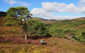
Covering nearly 423,000 square kilometers, the Kimberley region of Western Australia is one of the most sparsely populated areas on Earth, making it a haven for adventurers seeking solitude and unspoiled natural beauty.
Today, it’s a popular scenic drive that takes you through the heart of the Kimberley, which is known for its stunning natural beauty. Along the way, road trippers will pass towering gorges, crystal-clear waterfalls, and miles and miles of rugged, untamed landscapes.
The coastline is equally breathtaking, featuring some of the world’s most pristine beaches, untouched coral atolls, and rugged islands teeming with diverse marine life.
Kimberley coastline
The road’s popularity as a scenic drive has grown exponentially in recent years, as more travelers are seeking out off-the-beaten-path adventures in Australia.
While The Gibb River Road has grown in popularity, the road hasn’t changed much since it was a former cattle route and is also known for its challenging and adventurous terrain, which is a mix of sealed and unsealed sections, river crossings, loose gravel, and rough, rocky terrain.
Be prepared for the remote and isolated nature of the road, with limited access to services and facilities, including cell service, gas stations, and grocery stores.
Time to see why the Kimberley is my favorite region in Australia. Putting this post together has made me miss it immensely!
Map of the Gibb River Road
To help you plan your trip, here is a helpful map of the Gibb River Road including the attractions mentioned in this guide, the hotels you can stay at, fueling stations, repair shops, and more.
Read more: 7 Handy Tips for Driving in Australia
Essential to Know before You Go: Best time to Drive the Gibb River Road
River crossing time
This is not a summer adventure! In the north of Australia summer is really the wet season. Gibb River Road is often closed during the wet season, which generally runs from December to April as river crossings become impassable or sections of road have been damaged and may be dangerous.
The Gibb River Road is open from April to September is graded once at the start of the dry season, around late March or early April, which makes for a smoother road that’s easier to navigate.
April and May – early in the dry – are usually the best months to travel on the Gibb River Road when the waterfalls are in full stream and the road graded. As the dry season continues, several of the waterfalls will turn into a trickle or dry up, and the road will be become more corrugated and difficult to drive on.
Always check the road opening information and condition with Western Australian mainroads, as the exact date the road opens and closes depends on the weather and the road conditions.
The Gibb River Road Trip Itinerary
Day 1: Broome
The colors of Broome!Where to Stay: Mantra Frangipani Cable Beach, RAC Cable Beach Holiday Park
Where to Eat: Sunset Bar and Grill (Cable Beach), Matso’s Broome Brewery (Roebuck Bay)
Fuel stop: Ampol Foodary Broome North
Grocery store: Woolworths
While there is an airport in Derby, it’s small and doesn’t have a huge number of operating flights, so chances are you’re more likely to arrive in Broome to begin this adventure.
Instead of hiring your vehicle and hitting the road, spend a day (or longer) exploring Broome, which is one of our favorite towns in Australia.
Broome is famous for the idyllic Cable Beach, known for its stunning white sand and turquoise waters, making it an ideal spot for swimming, sunbathing, and camel rides at sunset.
Cable Beach
Walk along to Gantheaume Point, famous for its red rock cliffs and well-preserved dinosaur footprints that are only visible during low tide.
If you time your visit between March and October and you’re in Broome during a Full Moon, be sure to check out the beautiful Staircase to the Moon, a natural wonder that occurs when the full moon rises over the exposed mudflats of Roebuck Bay, creating a stunning optical illusion.
Another unique attraction to check out while in Broome is the Horizontal Falls, a natural phenomenon where the tides meet between two narrow openings between two escarpments, creating the illusion of a waterfall running on its side. It’s loads of fun to zip through it in a speed boat. You can only do this on a tour – as experts need to know how to time the run through the falls.
The tides in this region are some of the biggest in the world and can reach a difference of up to 12 meters. The pearl farm was around the corner from this area. Those tidal movements are insane!! This area is incredibly beautiful and worth visiting, especially the scenic flight in over the Buccaneer archipelago.
The Buccaneer archipelago
Broome has this wonderful, laid-back vibe with vibrant markets and a thriving arts scene, making it a worthwhile place to spend a few days for relaxation before setting off on a bumpy adventure!
Day 2: Broome to Derby
Aerial view of Derby Mudflats | credit: Tourism Western AustraliaDrive time: 2 hours 30 minutes
Distance covered: 221 km
Where to Stay: Dumbara Burru Caravan Park, Mud Crab Motel
Where to Eat:Neaps Bistro
Fuel stop:Shell Derby (diesel only)
Grocery store:Woolworths Derby
Now it’s time to set off on the Gibbs River Road adventure! The first section between Broome and Derby will be relatively easy to drive and is still in civilization.
Once you arrive in Derby, make sure you take time to visit the Boab Prison Tree and the Wharfinger’s House Museum.
Day 3: Derby to Windjana Gorge National Park
Drive time: 2 hours 15 minutes
Distance covered: 146 km
Where to Stay: Bandilngan (Windjana Gorge) Campground
Where to Eat: No restaurants, prepare your own meals
Fuel stop: None
Grocery store: None
Set off early from Derby and head out onto the Gibb River Road. This is where the road trip officially begins. Say goodbye to tarmac and concrete, because for the next two weeks, you’ll encounter more gravel, potholes, and rocks than you’ll want to see in your life!
15 minutes into the drive along the Gibb River Road is your first cattle station of many; Birdwood Downs Station. This is a working cattle station that also operates as an Indigenous training and employment center, where you can get your first unique insight into the local community and culture.
Stay a while and walk around, before hitting the open road again.
Just before you reach Lennard River Crossing, take a right down Fairfield-Leopold Downs Rd (350) for a short detour to the beautiful Windjana Gorge National Park and explore the stunning gorge that cuts through the Napier Range for 3.2km.
Walk along the Gorge Trail, and admire the unique fossilized limestone walls of the cliff’s face, which is made from ancient coral stone. Although the gorge has beautiful pools, you might be tempted to take a dip, but you’ll want to leave your bathing suit in the car for this one as this park is home to resident freshwater crocodiles.
Credit: Tourism Western Australia
I could not believe how many there were basking in the sun on the river banks! Freshwater crocs aren’t anywhere near as dangerous as saltwater crocs – in fact we have swam in several places in the Top End where they are. But, there were too many at Windjana for me to do it. Always talk to locals first because their are of course risks, but you never want to go in any waters where saltwater crocodiles are.
Spend the night at the campground in the national park and cook your meals under the stars.
You are now entering off-grid territory on this great Australian road trip. There is limited cell service inside the national park (be prepared for it to not work at all) and there are no restaurants, grocery stores, or fuel stops. You will need to prepare your own meals, and if you want to cook, bring a camping stove with you.
Day 4: Windjana Gorge National Park to Dimalurru (Tunnel Creek) National Park to Bell Gorge
Dimalurru (Tunnel Creek | credit: Tourism Western AustraliaDrive time: 35 minutes to Tunnel Creek NP, 2 hours 15 minutes to Bell Gorge
Distance covered: 36 km to Tunnel Creek NP, 160 km to Bell Gorge
Where to Stay: Bell Gorge Wilderness Lodge, Imintji Community Store and Campground
Where to Eat: No restaurants, prepare your own meals
Fuel stop: None
Grocery store: Imintji Community Store and Campground (basic supplies only)
Wake up early and drive for 30 minutes along Fairfield-Leopold Downs Rd to Dimalurru, also known as Tunnel Creek, National Park.
Dimalurru is known for its huge limestone cave, which is 20 meters high by 15 meters wide, and dates back 350 million years! It was formed by water, which carved a large tunnel into the limestone cliffs.
There is a 750-meter tunnel you can walk through, which is home to bats and freshwater crocodiles. Take a torch and wear sturdy footwear when exploring the cave. Yes there are freshies in here, but as I said, they aren’t aggressive and the only attacks known are because they have been provoked by idiot humans.
We didn’t see any on our walk through tunnel creek. It was an adventure worth taking!
Afterward, drive back along Fairfield-Leopold Downs Road towards the Gibbs River Road, where you’ll continue to Dalmanyi (Bell Gorge) and set up camp or stay at a nearby station.
Day 5: Bell Gorge to Adcock Gorge, Galvans Gorge & Manning Gorge
Swimmers at Bell Gorge | credit: Tourism Western AustraliaDrive time: 1 hour
Distance covered: 64km
Where to Stay: Manning Gorge Campground
Where to Eat: No restaurants, prepare your own meals
Fuel stop: None
Grocery store: Manning Gorge Campground has a small store for basic supplies only
This is going to be one GORGEous day! There aren’t a lot of places you can swim in the Top End of Australia thanks to the saltwater crocodiles, so when the opportunity arises you do not waste it. Today you’ll be exploring some of the best swimming holes and gorges on the Gibb River Road.
First, one of the highlights along the Gibb River Road is Bell Gorge. It’s a tranquil, horseshoe-shaped gorge with a cascading 100m waterfall. Many will make the journey along the Gibb from Broome just to see Bells and then they’ll return back.
Spend the morning at Bell Gorge, swimming in the clear pools and enjoying the stunning waterfall. There is a bit of a walk to the Gorge but it’s not too challenging and involves a small amount of rock scrambling.
Next was my favorite Kimberley gorge, the lessor known Adcock gorge, about 40 minutes from Bells. A 5km road along a 4WD track off the Gibb will take you to a beautiful oasis with very few people. We had it all to ourselves and we free camped here overnight beside the small lily pond and had it all to ourselves. But I have heard camping is no longer allowed here.
The clear, green pool is surrounded by ferns and grasses and has a small waterfall. There are rock ledges you can drop off (the water is really deep BUT always check!!)
Galvan’s Gorge
After a refreshing swim, pack up and head on to Galvan’s Gorge, another refreshing swimming hole with a cascading waterfall and a natural pool. Galvan’s Gorge was one of my favorite swimming holes on the Gibb River Road.
Galvan’s Gorge also has beautiful aboriginal rock art and a boab tree at the top. There’s a rope on the right side of the pool and we could even sit under the waterfall!
Manning Gorge
Drive on to Manning Gorge, the last swimming hole of the day, accessible by a 3km hike. Since the hike is a bit long, it’s a good idea to do this hike late afternoon when the sun isn’t so strong, and you can cool off next to the picturesque waterfall and swimming hole.
Alternatively, if you’ve had enough swimming for one day, you can catch a morning swim before setting off the next day.
Camp at the Manning Gorge Campground.
This is where we turned around and went back to Broome when we explored the western part of the Gibb River Road. Unfortunately, we all had to get back to work on the pearl farm!
Day 6: Manning Gorge to Drysdale River Station
Self Drive, The Kimberley, WA | Credit: Tourism AustraliaDrive time: 3 hours 15 minutes
Distance covered: 174 km
Where to Stay: Drysdale River Station Campsite
Where to Eat: Drysdale River Station Campsite has a cafe
Fuel stop: Fuel is available at Drysdale River Station Campsite
Grocery store: small store inside Drysdale River Station Campsite
If you decided not to swim in Manning Gorge the previous day, wake up early to do the 3km walk to Manning Gorge and enjoy a refreshing dip in the swimming hole.
There are not many attractions between Manning Gorge and Drysdale River Station, but the scenery is phenomenal! You’ll meet many river crossings and pass by miles of untouched wilderness.
Drive slow and take in the scenery on this chilled day of adventuring, and then fuel up at Drysdale River Station. This is one of the few places where you can get fuel, and pick up small grocery supplies before heading north to Mitchell River National Park.
Do some laundry, cook in the camp kitchen, or dine at the onsite restaurant. Enjoy the quiet retreat in civilization while you can, as it’s back to nature the next day…
Day 7: Drysdale River Station to Mitchell Falls
Mitchell Falls, Mitchell River National ParkDrive time: 3 hours
Distance covered: 158 km
Where to Stay:Mitchell Falls Wilderness Lodge
Where to Eat: Ungolan Pavilion at Mitchell Falls Wilderness Lodge
Fuel stop: None
Grocery store: None, but you can order a packed lunch from APT Mitchell Falls Wilderness Lodge
Drive on to Mitchell River National Park, home to the majestic Mitchell Falls. Stop in at Wandjina and Gwion Gwion (Bradshaw) Rock Art Sites on the way and admire the ancient rock engravings.
Park up by Mertens Creek, and hike 8.6km to Mitchell Falls. The trail is quite challenging with some rock scrambling and can take around 4-5 hours, but it’s worth it to see these huge four-tiered waterfalls cascade over red sandstone cliffs!
Alternatively, you can take a scenic flight from the campground, which is a great way to see the falls from above without the effort of hiking.
There will be no swimming in this national park, which is home to saltwater crocodiles and freshies.
Relax at APT Mitchell Falls Wilderness Lodge in the evening, which is a luxury campground with an onsite restaurant under the stars.
Day 8: Mitchell Falls to Kalumburu Mission
Winyalkan Island, near Kalumburu | credit: Tourism Western AustraliaDrive time: 3 hours
Distance covered: 160km
Where to Stay: Coconut Lodge
Where to Eat: No restaurants, though there is a campsite with a kitchen you can use at Coconut Lodge
Fuel stop: Unleaded and Diesel are sold on Wednesday and Saturday mornings between 8.00 am – and 10.00 am only from the Outback Store
Grocery store: Kalumburu General Store
Drive on to Kalumburu Mission, a place rich in Indigenous culture. It’s the most remote permanent settlement in Western Australia and is home to just over 400 residents, mostly of Aboriginal heritage.
There is a visitors center, which uncovers the history of the communities that have settled here, and not much else.
Visit Kira Kiro Artists to watch Indigenous artists at work and purchase some paintings to take home, and walk around the town and take in the sites.
The appeal to Kalumburu is to appreciate its solitude and remoteness. It doesn’t have much in the way of attractions, so if you do decide you want to cut your drive short, this would be the destination to skip.
Day 9: Kalumburu to Drysdale River Station
Amazing scenery | credit: Tourism Western AustraliaDrive time: 3 hours 25 minutes
Distance covered: 205 km
Where to Stay: Drysdale River Station Campsite
Where to Eat: Drysdale River Station Campsite has a cafe
Fuel stop: Fuel is available at Drysdale River Station Campsite
Grocery store: small store inside Drysdale River Station Campsite
There isn’t much on the way from Kalumburu to Drysdale River Station, since you’re driving along the road you’ve already been on.
Fuel up at Drysdale River Station, if you were unable to get fuel at Kalumburu, do laundry, relax by the river, and enjoy a home-cooked meal.
Day 9: Drysdale River Station to Home Valley Station
Home Valley Station, The Kimberley, WA | Credit: Tourism Western AustraliaDrive time: 3 hours 50 minutes
Distance covered: 236 km
Where to Stay: Home Valley Station
Where to Eat: Home Valley Station has a restaurant
Fuel stop: None
Grocery store: None
Drive to Home Valley Station and admire the stunning landscape along the way. Stop off at Cockburn Ranges Lookout to enjoy the views.
Aim to get to Home Valley Station by early afternoon, as there’s much to see and do here.
Home Valley Station is a working cattle station that allows visitors to experience life on a remote cattle station, including taking part in horse riding, cattle mustering, and even a scenic helicopter flight.
Day 10: Home Valley Station to El Questro Station
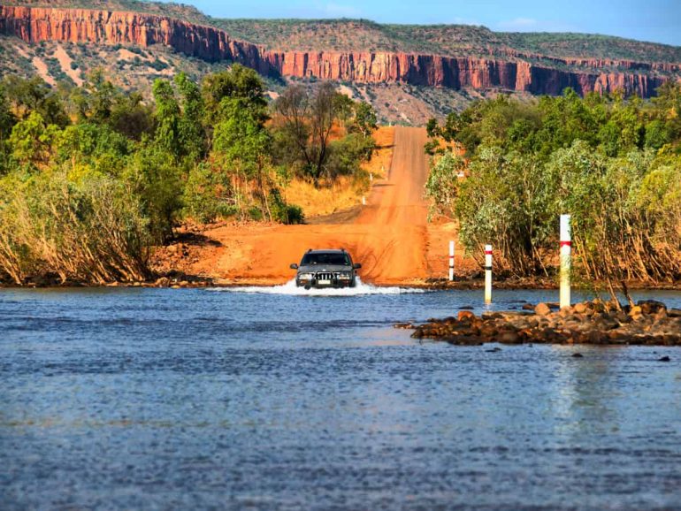
The legendary Pentecost River Crossing. | credit: Tourism Western AustraliaDrive time: 1 hour
Distance covered: 50 km
Where to Stay: El Questro Station
Where to Eat: El Questro Station has a Steakhouse restaurant
Fuel stop: El Questro Station has diesel and unleaded
Grocery store: None
In the morning, head up to the Pentecost River and take a guided fishing tour or go for a scenic hike. Here’s the moment many travelers either dread or are super excited about. It’s guaranteed to give you a story to tell. It’s the crossing of the Pentecost River. And yes, by that I mean driving through it. There are no bridges.
The river can be 60+ metres wide and the water often flows quickly just after the end of the Wet Season. The high water levels and flow of the water can exert extreme pressure on the side of the vehicle.
This is why you need a high clearance 4WD – that also includes your caravan / travel trailer. And you want to know what you are doing. I’ve heard stories!! Many people come to the crossing just to watch the cars cross it – and the many crocs just hanging about hoping for a quick snack.
The river gets lower by the end of the dry season and is easier to cross.
This is where we reversed when we were coming along the Gibb from the East.
El Questro
Once safely across you can drive over to El Questro Station, your rest stop for the night, and spend the afternoon at Zebedee Springs, a natural thermal spring located within El Questro Wilderness Park.
Zebedee Springs was one of my highlights in the Kimberley region. It’s a little tropical oasis with palm trees surrounding the terraced thermal pools and waterfalls.
Zebedee Falls
Head up to Saddleback Ridge and look out for sunset and incredible views over the remote wilderness. We really enjoyed staying at El Questro Station and we stayed here for two nights. It would have been more but we all had to quickly leave when a fire sprang up nearby and threated the area!!
It was a little scary, especially since we were meant to be hiking on the trail (it’s on your itinerary for tomorrow) where it started but we turned around as it was too long of a hike for the girls and we went to Zebedee instead.
Day 11-14: El Questro Station to Kununurra
Emma GorgeDrive time: 1 hour 25 minutes
Distance covered: 102 km
Where to Stay: Hotel Kununurra, The Kimberley Grande Resort
Where to Eat: Gullivers Tavern
Fuel stop: Shell
Grocery store: Coles Kununurra
Wake up early and take a walk on El Questro Gorge Walking Trail, a 9.1 km hike through a narrow spring-fed creek surrounded by beautiful rainforest and crystal clear swimming holes. The hike is an out-and-back trail and should take around 3 hours.
Drive on to Emma Gorge, another beautiful swimming hole that breaks up the ride between El Questro Station and Kununurra. There’s a gorgeous walk into Emma Gorge and the gorge itself is surrounded by moss and fern covered high cliff walls. It’s truly beautiful. But, the water is freezing!! It was a quick refreshing dip for us!
Once you’re in Kununurra, you are back in the land of civilization where grocery stores exist and fuel is easy to come by!
Spend 2-3 days in Kununurra and explore the many attractions there. The town is surrounded by stunning natural attractions such as the Ord River, Lake Argyle, Mirima National Park, and the Bungle Bungle Range. You may want to save Lake Argyle and the Bungle Bungle Range for the drive back to Broome if you are journeying back that way (more on this later).
Ord River, Kununurra| Credit: Tourism Australia
The Ord River is a waterway famous for its picturesque boat cruises, which are also integral to the region’s agricultural history. The Ord River Irrigation Scheme transformed the landscape and provided a vital water source for farming in the area.
Mirima National Park, also known as Hidden Valley, is known for its striking landscape of rugged sandstone formations and unique rock formations. The park has a cultural significance to the local Miriwoong people and features many walking trails with panoramic views of the surrounding area.
Kinununrra, East Kimberley Credit:
Tourism Australia
Explore Black Rock Falls, a majestic waterfall that’s also a nice spot for a swim, or visit Kangaroo Haven, a wildlife refuge for orphaned kangaroos.
Visit Waringarri Aboriginal Arts, and admire the aboriginal artwork, or learn about the history of the Kimberley region at the Kununurra Museum.
There is so much to see and do here, don’t think your adventures are over just because you’ve come to the end of the road!
Getting Back to Broome
Kununurra
If you want to drive back to Broome from Kununurra, then fortunately, you don’t have to drive back along the 4WD track. You can take Interstate 1 from Kunurra to Broome, and enjoy a nice, flat paved surface and serene outback views all the way.
Unfortunately, it’s an 11-hour drive, so you’re going to want to break this up!
I suggest taking 3-4 days to drive back, stopping off at some of the beginning stops of the Savannah Way road trip, which extends from Broome to Cairns.
On the first day, stop off at Lake Argyle, one of the few places in Western Australia’s Kimberley region where you can safely swim!
Lake Arygle is awesome
Sine Lake Argyle is a vast man-made reservoir and Western Australia’s largest and Australia’s second largest lake. Since it’s filled with fresh water, you might see a few freshwater crocs, but they aren’t to be scared of.
Go for a sunset cruise or fish in its expansive waters, kick back, and relax at a lakeside resort. After all the bumpy roads you have endured, a bit of luxury is well deserved.
Bungle Bungles from the air
The second day should be spent exploring the Bungle Bungle Range in Purnululu National Park, a UNESCO World Heritage-listed site featuring stunning orange and black striped domes, which look like giant beehives. This ancient Aboriginal site dates back millions of years and is well worth the detour, not only to see the impressive sandstone rock formations but to glimpse at some aboriginal rock art.
Cathedral Gorge, Bungle Bungles, Purnululu National Park, | Credit: Australian Pacific Touring
After seeing the Bungle Bungles, drive on and spend the night in Halls Creek, which will break up your journey on the following day. It’s also one of the largest predominantly Indigenous communities in Australia.
From Halls Creek, continue to Broome and make a stop at Fitzroy Crossing, a small town known for its aboriginal history. You can quickly stop in to explore the ancient rock art sites of the Gooniyandi people or enjoy a picnic on the banks of the majestic Fitzroy River.
Fitzroy will always be known to me as the second place in the world with the most mosquitos. The Everglades in Florida holds number one position. Man were they intense in both places!
From here on out it’s smooth sailing back to Broome.
Tips for Doing the Gibb River Road
Cockburn Ranges | credit: Tourism Western AustraliaRent an off-road vehicle. Most of this road requires a four-wheel drive vehicle, so you won’t be able to use a campervan (unless it’s off-road friendly).
Get a diesel car, if possible. Some gas stations are diesel-only along the route.
Check your tire pressures before you set off. The recommended tire pressure is 35 psi.
Pack a repair kit. You are driving on all terrain, so small mechanical issues can happen. There is a service shop in Derby Imintji Store and Balanggarra Home Valley Station for basic repairs if necessary.
Full up before you go and pack an extra fuel can (ensure it’s safely strapped down in your car). There aren’t many gas stations along the road. The fuel stations are in Derby Imintji Store (Diesel only), Mt Barnett Roadhouse Imintji Store (Diesel and Petrol), El Questro (Diesel and petrol), and Kununurra.
Download all maps and emergency numbers. There is no cell phone reception for most of the route, so make sure you have your maps downloaded and a list of your emergency numbers. Take a satellite phone, and buy a paper map, just in case.
Be mindful of crocodiles. This is croc-country, and you may see crocodiles in both fresh and saltwater spots. Don’t assume a place is safe to swim in unless it’s clearly stated it’s a croc-free place.
Get your photo with a boab tree (and try hug them!) The boab tree is the iconic botanical symbol of the Kimberley. They are found nowhere else in Australia. They’re known as upside down trees and are thought to have originally come from Africa. How? No one has quite figured that out yet!
Pick up your trash. Please respect the beautiful nature and Indigenous heritage of the attractions along the route, and leave each place as you find it (i.e. trash-free).
Bring cooking equipment. Many of the stops have no cooking facilities or restaurants, so you will need to cook for yourself.
Bring enough food for the whole trip. Grocery stores are few and far between, so bring enough food for each person for the whole trip, otherwise you’ll go hungry.
Take cash. There are no ATMs along the way and most places do not have the service for a card machine, so carry as much cash as you would need for supplies. The last ATM is in Derby.
Book accommodation in advance. Since this road trip has increased in popularity, you should book accommodation in advance to secure your spot, otherwise, it may be full by the time you get there.
FAQs about the Gibb River Road
Beautiful boabs | Credit: Tourism Australia
How long does it take to do the Gibb River Road?
The Gibb River Road is a scenic drive not to be rushed! While most people aim to take between 7 and 12 days, I can’t see how you can see all the amazing attractions in less than 12 days. I think a minimum of 14 days should be set aside to do this road trip, so you can spend a few days in Kununurra at the end, or spend a couple of days driving back to Broome.
Can you get fuel on the Gibb River Road?
Yes, you can get fuel along the Gibb River Road, but there are limited gas stations and some only have diesel and not petrol. The fuel stations on the route are Derby, Drysdale River Station, Kalumburu (limited), Home Valley Station, El Questro Station, and Kununurra.
Is there reception on the Gibb River Road?
No, there is very little phone reception along the Gibb River Road, so we recommend you download your maps and a GPS app so you can follow the route as you go. You can always use the WiFi in the hotels when you stop for the night.